Saturday, July 5, 2008

Alaskan Idyll, Day 17 Columbia Glacier Cruise


Today’s activity was a 9-hour cruise on the Stan Stevens excursion vessel Valdez Spirit. Billed as a glacier and wildlife cruise, this trip delivers on both counts. We normally try to limit the number of pictures we post, and we especially try not to post more than one picture of the same thing. We will warn you that we took over 500 photos on this cruise, and were not able to adhere to our normal practice. Hence, you will see four whale pictures instead of one. It’s so hard to choose!
The Valdez Spirit


Departing the Valdez small boat harbor, the boat passes through Valdez arm into Prince William Sound. On our way through the Port of Valdez we were treated to a close up view of the small boat harbor, with it’s myriads of fishing boats, and of our campground on the harbor channel.

Valdez Small Boat Harbor

Fishing Boats Abound in the Harbor

Passing our Campground on the Excursion Boat

Once into the main harbor there is a fine view of the pipeline terminal. We use the term fine advisably. Since 9/11 there has been an exclusion zone around the terminal, marked by prominent yellow buoys. We were told that the fine for violating this zone is $30,000!

$30,000 Fine to Pass on the Left

We also saw sea otter in the harbor. We were told that the fur is of exceptional quality and fineness, with up to one million hairs per square inch. The main activity of the sea otter is eating, floating on its back and resting.

Sea Otter Seen in Valdez Harbor

Eagles abound in the Prince William Sound area. While we were too far way from the shoreline to photograph the many nesting pairs we saw in the trees, we were able to photograph an eagle’s nest with a lone occupant.

Eagles Nest with Lone Lookout

Valdez Harbor exits into Prince William Sound through a one-quarter mile wide passage called Narrows. While it may seem wide, there was great concern about navigation of supertankers through the narrows when the pipeline terminal was built. All traffic is monitored by radar, and strict traffic lanes are established for large vessels. Ironically, the only serious oil spill occurred well past the narrows, where the Exxon Valdez ran aground on Bligh Reef in 1989. Our captain told a somewhat different story from what we all heard on the news back then. We guess you pays your money and you takes your choice of what you want to believe.


Approaching Valdez Narrows from Prince William Sound


Radar Tower on the Point at Valdez Narrows


Navigation Marker at Bligh Reef


Our Tour Boat Squeaks Through a Side Passage

Our boat turned west in Prince William sound, then turned north into Columbia Bay to view the Columbia Glacier. Columbia is a tidewater glacier, which means that the toe is afloat. Columbia is receding; there is no sheer face, and no dramatic calving.

Columbia Glacier

Because Columbia is receding, there is a substantial underwater terminal moraine in the middle of the bay, where the toe was located hundreds of years ago. Glaciers scrape up and entrain significant quantities of rock and loose stones as they descend. When the toe of the glacier sits in one place for a long time, this load of rubble accumulates on the bottom of the sea as the ice melts and drops its load. This accumulated pile of rubble is called a moraine.

As the boat approaches the Columbia Glacier, the first thing one notices is thousands of “icebergs” drifting south from the toe. We put the word iceberg in quotes to denote its use in the generic sense, as meaning a chunk of ice floating in the water. According to our guide, there are really four different classes of bergs. The smallest, less than 3 feet, are called brash. Chunks from 3 to 7 feet are called growers, while those from 7 to 15 feet are named bergy bits. Only those over 15 feet are permitted the designation iceberg. Bear in mind that 9/10 of the berg is underwater, so that even the smallest fully fledged iceberg is substantially larger than the nominal 15 feet. For what it is worth, our captain maneuvered very carefully so as not to bump into these larger chunks. We were very grateful for this. One can often see critters resting on the floating ice.
Iceberg Floating in Prince William Sound,
With Hinchinbrook Island in the Background

Harbor Seals Resting on a Bergy Bit


Harbor Seals Frolicking near the Bergy Bit

Glacial moraines can be quite large. There is a very large moraine south of New York and Connecticut, named Long Island. The ancestral moraine from Columbia glacier is underwater. On both sides of the moraine, seaward and landward, the water is about 800 feet deep, whereas it is only 35 feet deep over top of the moraine. Because this water is so shallow, many of the larger bergs broken from the present day tip, further up the bay, ground on the moraine as they drift south. We approached the moraine near low tide, so that the high water mark was clearly visible on some of the grounded glaciers, as shown below.

High Tide Line Etched Into an Iceberg Grounded on Glacial Moraine

Exiting the Columbia Bay, we turned west for a few miles, then north into Unakwik Inlet to view Meares Glacier. Along the way we spotted this pretty waterfall.

Waterfall Seen on the East Shore of Unakwik Inlet

You might think you seen one glacier, you seen them all. Not so. Columbia and Mears glaciers are quite different. The first difference is that Mears Glacier is advancing. In contrast to Columbia, the face of Mears Glacier is high and shear, with large facets of fresh ice in view. We hung around the face for about 15 minutes waiting for action, but did not see any major calving activity. The sun began to peek through the clouds as we approached the glacier face, so the view was spectacular, even without the calving action.

Panoramic View of Mears Glacier


Close Up of the Glacier Face


Close Up of Keith Waiting Patiently for a Calving Event

Close Up Showing Dirt Entrained in the Side of the Glacier


Our Boat Stirs Up Glacial Flour Suspended in the Water

We saw many humpback whales throughout the day. One of the more interesting sightings occurred near the end of the day when we came across a whale blowing bubbles in a circular motion. Our guide told us this is a feeding activity and he was attempting to corral the fish in the area for his evening meal. This is unusual behavior for a humpback whose main diet consists of plankton and krill.

Characteristic Humped Back of a Humpback Whale


Humpback Whale Frolics With Seal Lions


Humpback Whale Becomes Annoyed with Sea Lions and Prepares to Dive


Classic Humpback Fluke Display

We also came across a small flock of puffins. There are 2 types, the Horned Puffin and the Tufted Puffin. They are very fast and elusive birds, but we were able to capture a few images.

Puffin Takes Flight as Our Boat Approaches

On our return from Mears Glacier we passed close alongside a colony of Sea Lions at Bull Head. We were told that these are mostly juvenile males, kicked out of the nearby rookery by the more mature, dominant males. Basically, it’s a hangout for teenage guys, and as you might expect they were bellowing boisterously.

Bull Head

Teenage Sea Lions Hang Out in the Hood at Bull Head

Returning to the harbor we passed near a number of boats engaged in purse seine fishing. With this technique, the boat sets a long seine across the current to trap fish. An auxiliary skiff is used to haul the outboard end of the net, which hangs down about 30 feet, and is left in place for an hour or two. At the end of this period, the skiff draws the loop closed. A drawstring is then pulled through the bottom of the net to close it, forming a purse, for which the method is named. The closed purse is pulled aboard to recover the trapped fish. After recovery, the fish are off loaded to a larger vessel for transport to the processing plant, allowing the fisherman to continue fishing without interruption.

Fish Boat Setting a Purse Seine

An Auxiliary Skiff Hauls the Net in Place

Recovering the Purse Net

Off Loading to the Buy Boat

Our day of cruseing was punctuated with a tasty lunch consisting of chicken on a bed of rice, smothered with Alfredo sauce. Late in the afternoon we were treated to clam chowder. We returned to the dock at 7pm, a group of tired but very satisfied WIT campers.

Friday, July 4, 2008

Alaskan Idyll, Day 16 Valdez


Valdez is probably our favorite Alaskan town. It retains a small town America feel that has faded from the more tourist oriented towns such as Seward, Homer, Skagway, etc. The primary economic support for Valdez comes from the Alyeska Pipeline terminal, and from fishing, as opposed to tourism. The Vladez 4th of July Schedule of Events exemplifies the Americana atmosphere:

9:00am 10K Freedom Run
9am-6pm Free Admission to Valdez Museum
11:00am Independence Day Parade
& Kids Decorated Bike Parade
11am-3pm Fairbanks Street Block Party
11am-3pm Fire Department Exhibition
12:00pm Live Music w/ the “Moon Dogies”
12:30pm Kids Flag Tag
1:30pm Kids Games
2:00pm Connex Art Exhibition
3:00pm Canoe Jousting
5:00pm Free Community BBQ
6:30pm Freedom Swim
8pm-11pm Community Bonfire
8pm Live Music w/ “Mosquito Creek”
8:30pm Marshmallow Games
11:00pm Fireworks

We participated in some of this activity, as permitted by the WIT touring schedule. In keeping with the spirit of the day, Keith erected our flag.

Keith’s 4th of July Statement


At 9am we boarded a bus for a town tour, which included a ride around the end of the bay to “Winnebago Point”, which takes it’s name from the waterfront campground visible across the bay from the town. Located just past Winnebago point is the entrance to the Aleyska pipeline terminal. Prior to 9/11, Alyeska operated a visitors center and provided tours of the terminal. The visitors center is closed and visitors are no longer permitted in the terminal, so you dear readers will have to be satisfied with a photo from across the water. Also visible in this photograph is an emergency response barge. There are three of these vessels anchored in the bay, waiting for the next Exxon Valdez incident.

Emergency Response Barge, with Alyeska Pipeline Terminal in Background


Supertanker Docked at the Alyeska Pipeline Terminal


Valdez as Seen from Winnebago Point


On the ride out to the point, numerous eagles were spotted, sitting in the trees, and flying with the seagulls.

Bald Eagle Takes Flight

On our way back from Winnebago Point we toured the old Valdez town site, which was devastated in a severe 1964 earthquake. Our bus driver was a young girl living in the old town when the quake occurred. She described her experiences trying to descene a moving, bucking stairway and exit her residence. She told us the violent shaking persisted for 5 minutes, and was exacerbated by the fact that the town was built on poorly compacted glacial outflow soil. After the quake, the old town was abandoned, and the current town was constructed from scratch, on bedrock. Near our campground, in the new town, is a building moved from the old site.

Aerial View of Old Town Valdez, Destroyed in the 1964 Earthquake


Site of the Old Valdez Post Office


Historic Building, Moved from Old Town


While we were riding, our guide told us the story about how a small dog from a visiting motorhome was snatched by and eagle at a now abandoned Tesoro station 15 years ago. By interesting coincidence, Keith and his son, and his friend Richard, stopped to buy gas at this station the day after the incident in 1993. The attendant was telling everyone about the story, but we thought he was just funning the tourists, until we heard it on the national news.

Site of the 1993 Eagle Snatching

Following our visit to the old town, we toured the new town. We drove up Hazelet Avenue as the parade was assembling, so were treated to a preview. We also drove through a residential area, and past a few schools and museums. Most importantly, we were shown where the free food was to be served at 5pm.

Lunch was left over Shepard’s pie (4 COWS), followed by a nap for Keith. Later in the afternoon we visited the local Safeway, then drove by the town museum to snap a few photos of the outside exhibits. We were too tired to avail ourselves of the free 4th of July admission, but will return on Sunday morning as paying customers, when we are bright eyed and bushy tailed.

Among the exterior displays at the museum is a cutaway section of pipeline with a cleaning plug, called a “pig”, and a lifeboat from the Holland American Cruise Ship Prinsendam. In October 1980 this vessel embarked from Vancouver on a 30 day Pacific cruise. Three days later the engine room caught fire, and the vessel sank in the Gulf of Alaska. All 524 hands boarded lifeboats and were rescued, but it must have been a harrowing experience. A book titled “Burning Cold” has recently been published about the dramatic rescue.

1980 AP Photo of the Sinking Holland American Cruise Boat Prinsendam

Lifeboat From the Sunken Prinsendam
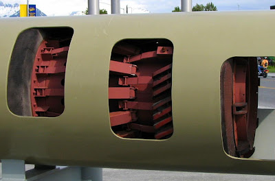
Pipeline Cutaway Showing Cleaning "Pig"

At 5pm we drove the short distance to Ruth Pond to avail ourselves of the free BBQ. Burger, chips, chocolate chip cookie, and pink lemonade, served with a smile and enjoyed at an outdoor picnic table overlooking the harbor. It was as American as Apple Pie.

After dinner we read and blogged for a while, then Keith went to enjoy an ice cream social with the caravan group.

WIT Caravaners Enjoy an Ice Cream Social

We retired after ice cream, but were awakened at 11pm by some very loud bangs just over our heads. Kathy raised the rear shade, and we were treated to a very nice bedside fireworks show from the mountainside. Tomorrow we embark on an all day Columbia Glacier Cruise.

Thursday, July 3, 2008

Alaskan Idyll, Days 14,15 Tok to Valdez


Yesterday was a “free” day on the caravan schedule in Tok. So what’s the first thing every RV owner wants to do on a free day in Alaska? Change their oil, of course! As seen below, the campground in Tok takes a very dim view if that activity.

No DIY Here!

In lieu of changing oil, we did more legitimate stuff like wash off 1500 miles of road grime in the campground RV wash. Keith then composed a couple of blogs, about the trip from Skagway, while Kathy cooked Shepard’s pie and did laundry. Altogether a chore-ish kind of day.

Today we drove 260 miles southwest, from Tok to Valdez. The day dawned bright and clear, like yesterday. The road, for the most part, was much better than the ride from Destruction Bay. It’s interesting how the road changes from year to year. We recollect the Glenn Highway (known locally as the Tok Cutoff) as one of the poorest roads in Alaska and the Yukon. There still are some bumpy stretches, but most of the former damage has been repaired, so our drive today was not unpleasant. For the most part, we were able to set the cruise control at 50 or 55 and just steer.

Not far out of Tok, the Wrangell Mountains come into view. We know, it begins to seem tiresome, one beautiful mountain scene after another, but we just can’t help but gush over each and every one.

More Boring Wrangell Mountains

A bit further down the Tok Cutoff the skyline is dominated by Mt. Sanford. At 16,237 feet, this peak is nowhere near as tall as Mt. McKinley, but it still dominates the south-central Alaska landscape. There seems to be much more snow on the mountain than we recall from our last trip, probably because it’s earlier in the season.

Mount Sanford

Near the Junction of the Tok Cutoff with the Richardson Highway, there is a beautiful overlook of the Copper River, with the Wrangell Mountains in the background. This is an excellent example of a braided river, in which multiple channels wander aimlessly back and forth across a broad gravel bed.

The Copper River Near Gakona
An Excellent Example of a Braided River Channel

Rolling south along the Richardson past Glennallen, the Alyeska Pipeline soon comes into view. This 800-mile pipeline carries crude oil from Prudhoe Bay, on the Arctic Ocean, south across the Brooks and Alaska Mountain Ranges, then through the Thompson Pass across the Chugach Mountains and down to the pipeline terminal in Valdez. Construction of this pipeline through the mountains and across the permafrost tundra was quite an engineering feat in the 1970’s. While parts of the pipe are buried, as are almost all pipelines in the lower 48, much of it is above ground, thermally isolated from the permafrost by very ingenious heat pipe supports that prevent the warm crude oil from melting the permafrost. These supports are visible in the photograph below.

Aleyska Pipeline, Supported Above the Permafrost on Heat Pipes

Along the pipeline are a 12 pumping stations. Each of these includes a small refinery, in which crude oil extracted from the pipe is refined into jet fuel, and a land based gas turbine powered pump, which uses this fuel to pump the crude further down the line. If this ain’t bootstrapping, I don’t know what is!

Alyeska Pipeline Pump Station Number 12

Rolling south from the pump station, the Chugach Mountains loom into view. Climbing up toward the pass, there is an excellent view of the Worthington Glacier.

Chugach Mountains Loom Into View, Together With the Rainclouds


Worthington Glacier


Also looming into to view as we roll south is a bank of clouds, presaging rain over the Gulf of Alaska. At the Thompson Pass, we bid a fond adieu to out fair blue skies, and say hello to the same gloomy weather we have experienced most of this trip. Fortunately, this weather does not dampen our spirits, or in any other way detract from the beautiful scenery. And in no way do we blame Winnebago Itasca Travelers (WIT) for this weather (LOL).

As we travel deeper into Alaska, we notice another phenomenon that is characteristic of this territory. This phenomenon is road signs which are pockmarked with bullet damage, such as is seen on this sign at the summit of Thompson Pass.

Bullet Damage Seen on Alaskan Road Signs

Fortunately, the local gun culture has not damaged the breathtaking natural beauty of the pass itself.

Thompson Pass, With It’s Head in the Clouds

Descending through the Keystone Canyon, the Bridal Veil and Horsetail falls come into view. We paused briefly to take a photograph at Bridal Veil.

Keystone Canyon

Bridal Veil Falls

We arrived at the campground promptly at the 2pm opening of the parking window, and were greeted by our ever faithful and cheerful parkers, Dave and Nancy, who parked us on the banks of the channel into the Valdez Small Boat Harbor.

After parking we ventured out for a bit of local cuisine. The Tesoro gas station we stopped at on the way into town recommended a little hole-in-the wall place called “Old Town Burgers”. It was no frills, but the food was excellent and plentiful. Kathy had halibut fish and chips while Keith had bratwurst (3.5COWS).

We are sitting at the dinette, watching the fishing boats pass in and out as we compose this message. We don’t know what season it is, but there is open season on some species of fish this weekend. Salmon season opened the day we were in Juno; we are guessing that is what they are catching today. In addition to the never-ending parade of boats in the channel, there are always 3 or 4 boast tied up to the Peter Pan fish plant dock. This kind of entertainment you can’t buy!

Valdez Small Boat Harbor, Seen from Our Windshield

An Endless Parade of Fishing Boats Passes By Our Campsite


Tomorrow, Friday, is a town tour, followed by a Glacier Cruise Saturday, and a free day Sunday. Stay Tuned.

Tuesday, July 1, 2008

Alaskan Idyll, Day 13 Destruction Bay to Tok


Today is Confederation Day in Canada. Also known as Canada Day, it celebrates the anniversary of Canada’s original Confederation on July 1, 1867, in Charlottetown, PEI. On our way out of the campground this morning, our tail gunner met us, dressed for the occasion.

Bob and Marilyn, All Dressed Up for Confederation Day


Our drive today was the worst piece of road so far. We recall the stretch between Destruction Bay and Tok being not too bad in 2005. Today it is a mess. The further north we go, the deeper we penetrate into permafrost territory. Permafrost is soil that stays frozen permanently. Our Destruction Bay host told us that the permafrost under his campground is frozen to a depth of 160 feet. Only the top few feet thaw over the summer. Because the subsoil is frozen, water in the thawed layer can’t drain away, so the surface turns into muck every spring. The soldiers who built the pioneer road did not understand permafrost. They built the road and parked their machinery directly on the surface of the frozen ground. In late spring, the road turned to muck, and some of the machinery, including whole bulldozers, disappeared in the mud.

Another characteristic of permafrost is that the surface layer heaves and buckles as it freezes and thaws every year. This happens because water expands about ten percent when it freezes. That’s why frozen pipes burst, and why ice cubes are not flat, but have bumps in the center. Pavement also develops bumps as it freezes and thaws. These frost heaves can severely damage the road surface in only a few seasons. The truckers hate pavement in this country because of these frost heaves. On unpaved roads, it is easy to grade out the damage every spring, leaving a good driving surface for the trucks.

Building roads over permafrost requires a special technique. In the lower 48, road builders dig down to install a thick base of crushed stone, which is covered in turn by smaller stone, then pavement. In the arctic, an insulating layer is laid overtop of the soil, to prevent melting of the permafrost as the high emissivity road surface absorbs solar radiation. The road surface is laid down overtop of this insulating layer.

Driving over frost heaves at high speed is a recipe for disaster. In Canada, the road crews put out (very) small orange flags at most of the heaves, but these small flags are hard to see, especially in rain such as we had today. The best advance warning of frost heaves is wiggles in the white line, as shown below.

The Wavy White Line Indicates Frost Heaves

Frost heaves also affect anything sitting on or planted in the surface soil. In marshy areas, the trees stick up every which way as a result of being moved about in the freeze-thaw cycle. These are called drunken forests, for obvious reasons. Telephone poles are also susceptible to this type of damage. We wonder if conversations over these lines sound inebriated?
An Example of a Drunken Forest

Drunken Telephone Poles

We have spotted a surprising number of bicyclists on the Alcan. That’s got to be doing it the hard way. We don’t know if these folks stay in motels, but the distance between accommodations, combined with the large number which are out of business, have almost got to force these cyclists to sleep outdoors many places. We do not consider this a safe practice, because of bears.

Traveling to Alaska the Hard Way

No Room at the Inn for Weary Cyclists (Or Anybody Else)

About halfway along our trek we crossed another border, passing from Canada into Alaska, again.

A Lineup at the Border


Welcome to Alaska, Again


Shortly after entering Alaska, we were treated to a magnificent view of the Tanana River valley, with the Wrangell Mountains rising in the distance. Along the way we also spotted more pretty wildflowers.

Tanana River Valley


More Pretty Wildflowers

We arrived in Tok about 2pm, an hour ahead of the caravan-parking window. No problem! We bought fuel, then relaxed over lunch at Fast Eddies, one of our favorite restaurants in Alaska. Tomorrow is a free day, then on to Valdez for a few days. We are looking forward to the waterfront campground in Valdez.