Monday, April 28, 2008

There and Back Again - Carson City, NV to Sutherlin, OR, including Mt. Lassen


Where in the World are Keith and Kathy?


Kathy returned from Massachusetts on April 22nd, after a 10 day sojourn to visit her family. She arrived in Reno just a few days before the recent earthquake. We have been reading about the numerous earthquakes in the Reno area, and are glad we left when we did. Experts are predicting a possible 6 plus in the near future

On Thursday April 24th we headed northwest for Mount Lassen Volcanic National Park. Lassen is a place that Keith visited on his cross country odyssey in 1965; he was anxious to see if it had changed in the intervening 43 years.

The ride from Carson City to Lassen was about 4 hours. Over the course of a hundred miles the scenery transitions from the semi-arid desertscape around Reno, to the alpine valleys and meadows of eastern California, to the pine forested heights around Lassen.

Changing Landscape North of Reno


Along the way, we stopped for second breakfast in Susanville, a pleasant little northern California town. Our friends, Richard and Carol, told us about a chain of diners called “The Black Bear”, and it was here we were able to have our first “Black Bear Experience”. Kathy’s daughter Paula would love the place; the décor is all about bears. The cuisine was “comfort food”; it was good and plentiful, rated at 3 COWS.
Black Bear Diner is Susanville, California


After Susanville the pine tree forests grew, and we started to see more and more snow as the elevation rose.
Out of the Desert


We arrived in Old Station, CA about 1 pm and registered at our home for the next two days, The Hat Creek Resort and RV Park. Unbeknownst to us, Hat Creek is one of the premiere trout fishing spots in northern California and we had arrived two days before the opening of fishing season. The campground was heavily wooded, so we had minimal/no cell, satellite or internet service, but we did have our first campfire of the winter, which we enjoyed very much. Our hosts were very accommodating, and on Friday evening grilled cheeseburgers for us (and for anyone else with $6.95 in their pocket).
More Sticker Shock in Old Station, California


The purpose of our stop in Old Station was to visit Mt. Lassen Volcanic National Park. The southern-most active volcano in the Cascade chain, Lassen experienced a series of eruptions between 1914 and 1917. Until Mt. St. Helens erupted in 1980, it was the most recent eruption in the Cascades.
Mt. Lassen National Park Entrance
Mount Lassen


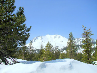
While the main park road is still closed with dozens of feet of snow (40 feet is typical), the park web site said the road had been cleared from the Manzanita entrance station to the devastated area. At least that’s what it said a couple of weeks ago. A couple of days before we arrived, the road was re-closed due to recent snows. Bummer! We nonetheless set out the next morning to see how far we could drive in, and found the road open again to the devastated area, past which it is still closed, probably for another month. We felt lucky.
End of the Road


Keith’s perception is that the landscape has changed since 1965, but not dramatically. The primary differences are more snow (that’s just April vs. July), and the trees seem taller. Shown below are two photos taken 43 years apart, from about the same spot. You make your own judgment; whatever change has occurred, it isn’t dramatic.
Slow Growth

Friday evening Keith became ill with an intestinal bug, and by Saturday morning was truly under the weather. Since Kathy was not sick, we decided it was probably a bug, as opposed to bad food.

We debated whether to stay an extra day at Hat Creek, or continue on to Timber Valley, an Escapee Park in Sutherlin, OR, where we planned to stay for a week. Keith insisted he was well enough to drive, so we set out on a 5 hour trek. After 80 miles of narrow two lane road we turned onto Interstate 5, and Kathy took over the driving for awhile.
Almost as soon as we left Old Station northbound on CA 89, we began to see Mt. Shasta, almost 80 miles away. At over 14,000 ft., Shasta is another major volcanic mountain in the Cascades chain. Highway 89 turns west to round the southern foot of Shasta, then joins I-5 which passes west of the mountain. Just north of Shasta is another impressive cinder cone.
Mount Shasta
Cinder Cone Just North of Shasta
California Retrospective
North of the Oregon state line the highway embarks on a series of long, relatively steep (6%) and winding grades. This was Kathy’s first experience with mountain driving, and she handled it like a pro.
Oregon Grades on Interstate 5
Early in the afternoon we arrived in Sutherlin, and Keith laid down and slept 12 hours non-stop.
Sunday morning we were awakened by the official Sutherlin welcoming committee. Keith is feeling much better and suggested we go out for breakfast. We decided to try the Apple Peddler Restaurant - 2.5 COWS (a west coast chain very similar to Denny’s,) and then stopped to buy one half dozen bagels at Bronx Bagels (also 2-1/2 COWS). It seems the only place to buy true New York Bagels in New York.
Timber Valley Campground Welcoming Committee


We hope to spend the next week with a pleasant combination of relaxation, chores (the dinette window shade is broken again), touring, and restauranting. There is a promising Chinese Buffet here in Sutherlin, and a couple of Thai restaurants up the road a piece in Roseburg. Stay tuned for phantom COW reports…

Thursday, April 24, 2008

Keith’s Technology Rant

Where in the World are Keith and Kathy?


The purpose of this rant is to rail against the complexity, complications, and frustrations that are attendant upon realization of the benefits of modern technology.

Things really are much better, technology-wise, than they were when Keith was growing up in the 1940’s. The telephone no longer has a wire, it’s available in more colors than just black, and there is one in almost everybody’s pocket(book). Computers have moved out of the esoteric University of Pennsylvania EE lab, and onto everyone’s desk and lap top. Teenagers, and a few savvy old farts, carry thousands of hours of music and audiobooks in their shirt pocket. Satellites tell us where we are, and where to go, with six foot precision.

But probably most significant is the recent quantum improvement in information archiving, management, and access, especially for the common man. We currently are experiencing an information revolution which is at least the equivalent of the invention of the printing press in 1450. I just looked up that date on the internet. In 1945, it would have taken a trip to the library, a consultation with the librarian, and probably a trip to the stacks to obtain that bit of trivia. (Does anybody remember library stacks?) Today it took me 90 seconds using Google. And I did it sitting in a campground in Old Station, California, using a Verizon wireless aircard.

Which brings me to the point of this rant.
Accompanying this explosion of technology is a corresponding increase in complexity, and frustration when it doesn’t all work right. Our current frustration has to do with EVDO (wireless) internet access, and the enabling Verizon service.

Our need for wireless internet is obvious; we travel half-time in our motorhome. We used to have a high speed cable modem in our Massachusetts Condo, but we needed something on the road. Dial-up is clumsy, inconvenient, and slow at best, and can be downright frustrating when traveling. Memories of juggling a laptop and a list of local access numbers while standing at a payphone come to mind. That is, if we could find a payphone with a data jack. Wi-fi is available in some locations, but it can cost as much as five dollars a day. So why not pay the $50 a month (when bundled with a cell phone contract), and have internet (often high speed internet) almost everywhere we travel, we thought. As an added benefit, we can use it as our primary service at the Condo, and loose Comcast, we thought.

So, in August 2006 we bought the aircard, and cancelled our Comcast (and pocketmail) accounts. This is beginning to resemble the story about the guy who jumped off the roof of a tall building. As he was passing the second floor, he was heard to loudly exclaim “so far, so good! We hit the pavement when we got home and discovered that the Verizon signal at the Condo was not strong enough to provide reliable broadband service, that we could not use the aircard with our desktop, and that only one of us could be on line at a time (this turned out to be a surprisingly large irritation).

Two weeks and five hundred dollars later, we had a Wilson induction-coupled cell phone amplifier and a Kyocera KR1 wireless router installed at the Condo. Why induction coupled, you may ask? Because the Verizon 5740 aircard does not have an external antenna jack, that’s why. These add-on’s pretty much solved both initial problems. The amplifier boosted the signal to where we had broadband most of the time in the Condo, and the wireless router allowed us to use the aircard on the desktop and laptop, simultaneously. Besides, we thought, we can take this whole show on the road, just with the addition of a couple of 12 volt power chords. We think it was very thoughtful of both Wilson and Kyocera to incorporate native 12 volt power requirements into their equipment.

This all worked just fine, for awhile. We could both be on line everywhere we went, from the New Hampshire mountains, to the rural Midwest, to Texas, and to the Southwest. We have been surprisingly few places in the lower 48 where we could not get a usable signal. Death Valley comes to mind as one of the few examples.

Then Kyocera router started to act up. Oh well, we said, we can live with sharing the internet until we can repair/replace the router. Then our laptop started giving us trouble. It didn’t die, exactly, but it did overheat, after which the USB port sort of didn’t work. We use the USB connection extensively for downloading photos and mp3 files, so we felt we needed to buy a new laptop for these functions. And,of course, we wanted to be able to use it with the aircard.

The first check was when we discovered that, over the course of 14 months, the world had moved on from PCMCIA cards, to Express cards. Since our air card is a PCMCIA, were forced to purchase a leftover laptop which still had this type of port. We wound up buying a Toshiba with both types, plus USB, which is great because it gives maximum forward flexibility.

Now we are faced with the issue of a flakey wireless router. While we were at the excellent February Gypsy Rally in Casa Grande, AZ, Keith spoke with Mr. Geek (of the very highly recommended www.geeksontour.com, enterprise), who suggested I try resetting the router. I’ve tried that, and it seems to help, some. The router now works better, after it warms up for an hour or two, and when the furnace is keeping ambient above 70 degrees. During warm up, or if we move the router to a cold location (like the cabover bed/storage area), it continues to drop the signal frequently.

So, Keith decided to call the 3G store, an excellent source of EVDO advice and hardware. The pleasant and helpful salesman said “yes, the KR1 does go flakey after awhile. No, it can’t be fixed; resetting helps sometimes, but your gonna have to buy a new router to have reliable service.” Keith said fine, what do you recommend? The recommendation was a Cradlepoint 350, for $150. And oh, by the way, your ancient, outmoded, obsolete ((20 months old!) PCMCIA card wont work with the new router, so you will have to upgrade to a newer, longer, lower, and faster new model (remember the 1950’s car ads?). He recommended the U720, which has a USB connector. Sounds good, as USB has become almost truly universal (except that the USP port is fried on our old laptop). But that’s OK, as long as the new wireless router works reliably. And oh by the way, the new air card has an antenna jack. Our old induction coupled amplifier will work with it, but our performance would be better if you bought a new amplifier with a plug-in connector, we were told.

That’s another several hundred dollars, to replace the five hundred dollars worth of stuff we bought 20 months ago. What’s wrong with this picture?

The 3G guy told me that the new U720 was $260 if bought outright, but could be had much cheaper if replaced under terms of my now-matured Verizon new-every-two contract. Then he warned me, “oh by the way, your old contract has unlimited monthly data; if you cash in your new-every-two, your contract will automatically be extended two years, and your new contract will include a 5GB monthly data cap, above which you will be charged 49 cents per megabyte”. He recommended that before I make a move, I review my historical data usage to determine if I am at risk of going over 5GB. I did that, and discovered that, while my typical usage over the past seven months was about 2GB, the past two months have been close to 5GB, with the Feb.-Mar. billing cycle being 5.98GB. OOPS! With unlimited monthly data, no sweat. However, under the new contract terms, that month would have left me with almost $500 in extra usage charges! So, If I upgrade, I’m gonna have to start policing usage like a hawk.

So now I’m left with the conundrum, do I upgrade for several hundred bucks to achieve improved reliability and performance, at the expense of becoming a megabyte ogre, or do I limp along with what I’ve got until my existing Verizon contract renews in early 2009, after which I’m stuck with the 5GB cap, period. I think the answer is going to be limp along, but I’m left terribly frustrated with how much complicated (albeit better) things have become since 1945, which started out as the whole point of this tirade.

Cheers!

Sunday, April 20, 2008

China Journals Announcement


We are Announcing that we have just completed retroactive publication of our journals and photos from a 26 day trip which we took to China last fall. These retro-posts may be found by rummaging in our Nov and Dec 2007 posts.


Travel Safe,


K&K

Monday, April 14, 2008

Carson City/Reno and Lake Tahoe

Where in the World are Keith and Kathy?

We arrived in Carson City on Sunday, April 6th. After an extensive search of campgrounds we decided to stay at the Gold Dust West casino, which offered a full service campground for a reasonable fee of $23.00/night. It was a good decision. We are surrounded by spectacular mountains and it is conveniently located near the 395 by-pass . When we arrived the casino gave us player cards which enabled us to eat for free or for a very reasonable fee at their coffee shop . The food has been 3COWS consistently.

On Monday we explored Carson City, visiting the local information center and the AAA for maps..

On Tuesday we decided to take a ride to Reno. Our first stop was West Marine for electrical connectors, and then onward to The National Auto Museum, which is listed as a gem in the AAA book. It was indeed a gem! The museum contained over 220 beautifully restored vintage automobiles, ranging from the 1907 Thomas Flyer, which was the winner of the 1908 New York to Paris Race, to a 1981 24 carat gold plated Delorean. Emphasis is on cars that are unique, or were owned by famous persons, or are significant milestones in the development of automotive technology. Examples of the former include James Dean’s ’49 Mercury, Elvis Presley’s 1973 Cadillac, a WW II German Staff car, etc. Technological breakthroughs such as the 1909 Model T and a 1911 Cadillac, the first car to have an electric starter, also were represented. We had a very knowledgeable tour guide who took us on a two tour that was of both mechanical as well as historical significance. Keith particularly enjoyed the collection of 1950 cars from his youth.

Welcome to Reno!

1909 Ford Model T

German Army WW II Mercedes Benz Staff Car


After lunch we took a ride down S. Virginia Street which is the main drag in Reno. It hasn’t changed a lot since we were here in 2004. Parts of it are casino glitzy, and parts are a little on the tacky side. Keith wishes to emphasise once more that Kathy takes these pictures.

The Tackier Side of Reno

On Wednesday we took a ride to Lake Tahoe by way of Spooner Summit Pass. It had snowed the previous night but fortunately the road was open. We drove into the town of S. Lake Tahoe and then up the east side of the lake to Interstate 80. It is a beautiful drive with the large blue lake taking center stage. Eastbound on I80 there are frequent views of the main railroad line across the Sierras. Keith and Kathy enjoyed a very pleasant train ride on this line a few years ago. Also visible are remnants of abandoned train trestles near the current tracks. Keith wonders about the age of these abandoned trestles. Could they be a remnants of the original transcontinental track which was hewn through these rugged mountains in the late 1860’s, or are they later generation structures? Keith doesn’t quite know how to research this.

The Road to Lake Tahoe

Lake Tahoe

Abandoned Railroad Trestle

On the way back we stopped at Cabella’s Sporting Goods Store. Cabellas is not just a store, it is a marketing phenomenon. Gear and clothing are sold for many outdoor sports such as hunting, fishing, camping, boating, etc. We had lunch at their grill. They feature various wild game on their menu. Kathy had a bison burger (3COWS) while Keith had fried halibut (1.5COWS). After lunch Kathy shopped and bought 5 sets of “Bear Paws”, one for each of our children. These are devices for safely handling hot meat, such as roasts. If any of you in New England are interested is seeing a Cabellas store, one just opened in East Hartford, Ct., on an abandoned airfield formerly owned by Pratt & Whitney. As a reminder, P&W provides Keith’s pension. Keith can recall flying from this airfield in P&W corporate aircraft many times in the 80’s and 90’s.

On Thursday Kathy toured the interior of the campground laundromat. On Friday morning we toured the local WalMart Supercenter, then drove a few miles east to Virginia City. For half a century, starting in 1859, over 400 million dollars in gold and silver was wrenched from the ground around this historic town. Huge scars from this mining activity are still apparent on the steep hillsides, and abandoned mining facilities dot the countryside. In the past hundred years, Virginia City has transformed itself into a tourist attraction, replete with opportunities for retail therapy.

Scarred Hillsides Near Virginia City

Abandoned Property

Virginia City Retail Therapy Zone


Saturday morning we awoke at 4am to take Kathy to the Reno airport, where she boarded the big silver bird bound for Massachusetts and her family. Sunday Keith moved to the Golden Nugget RV parking lot in downtown Carson City. No services, no cost, except what Keith will spend eating in the casino. Don’t know how long they will let me squat here. I hope they don’t notice that Keith doesn’t gamble. Stay tuned to learn the answers to this and other’s of life’s perplexing questions.

Monday, April 7, 2008

Route 395 North from Lone Pine, California to Carson City, Nevada


Where in the World are Keith and Kathy?


Over the last four days, we drove north from Lone Pine, CA, through the snow-capped peaks of the Sierra Nevadas to Caraon City, NV, pausing for two nights in Lee Vining, CA.

Leaving Lone Pine, Keith pulled over to the curb so Kathy could take a photograph of the movie museum. As shown below, Keith pulled over a little too far. Fortunately, the damage appears to be just cosmetic.

Curbside Souveneir


As we drove north, we snapped a passing pix of the reconstructed Manzanar watch tower, and of a satellite dish pointed straight up. Was this dish in an idled position, or are we in touch with ET? Only Art Bell knows for sure.


Manzanar Watch tower

ET Phone Home


North of the Owens Valley, Rt. 395 ascends in altitude and the temperature declines sharply. By the time we got to Lee Vining the 7000 ft. altitude was affecting both of us. On arrival at the campground, which just opened April 1, we were greeted by the official spring welcoming committee.
Welcome to Lee Vining

Spring Welcoming Committee


Lee Vining is in the Mono Basin Scenic Area, at the easternmost entrance to Yosemite National Park. During the summer season the town is bustling with tourist activity, but at this time of year the it is mainly deserted.

Where it Happens in Lee Vining


Because if the areas relative remoteness, gas prices are higher than further south in the Owens valley. Keith pumped $98 to top off the tank. We had enough in the tank to get us to Nevada, where gas is almost a dollar cheaper, but Keith tries to travel on the top half of the tank when in remote places.

More California Sticker Shock


On Saturday we set out to explore the area. Our first destination was Tioga Pass, which is the eastern entrance Yosemite National Park. However, the road was closed and we were only able to go about 4 miles. We were told that this road typically isn’t open until June.


The Eastern Face


The Road to Tioga Pass is Closed


Second on our morning agenda was Mono Lake. Nestled in the eastern ramparts of the high Sierras, Mono Lake exhibits three distinguishing characteristics. First, it is very scenic.

Second, Mono Lake is a mere shadow of it’s former self. A victim of “water wars”, which go back as far as the 1860’s, Mono Lake shrank dramatically in the second half of the twentieth century as the eastern Sierra watershed was diverted to feed Los Angeles. Recent court actions have started to reverse this diversion.

The third unusual feature of Mono Lake is tufa (not to be confused with tofu). Tufa is calcium carbonate precipitated from solution around underwater springs, as calcium contained in the spring water combines with carbon dioxide in the water. Because the solubility of this mineral is low, it precipitates in stalactite-like formations as soon as it is created. This process occurs exclusively underwater. However, as the lake has been drained in recent decades, the tufa formations have been exposed to view.


Exposed Lake Bottom

Mono Lake Tufa In Situ

Monument to the Necessary Functions


During the Cold War the navy used part of Mono Lake to test new weapons. Today there is a plaque commemorating the site.

Mono Lake Navy Monument


We had lunch at the only restaurant that was open in Lee Vining. Nicely’s was not so nice and a big disappointment, with very mediocre food and California prices to go along with it; $30 for very mediocre food. We rate it 2COWS at best.

The ride north from Lee Vining is, in our humble opinion, the most spectacular piece of 395 between Lone Pine and Carson City. The view south from Conway Summit Pass (8128 ft.) includes a spectacular vista of the snow-clad eastern Sierra ramparts, with Mono Lake sitting at the mountain’s feet. Further north, the road descends through a rugged canyon cut by a vigorous mountain stream. At the mouth of this canyon is the almost bucolic Antelope Valley.

High Sierras Overlooking Mono Lake

Canyon Drive

Antelope Valley


It now is Monday, the 7th, and we are camped for a week at the Gold Dust Casino “resort” on the outskirts of Carson City. We plan to tour the area during the week. On Saturday, Kathy flies east to Massachusetts for a grandchild fix. Stay tuned.

Friday, April 4, 2008

Lone Pine, California

Where in the World are Keith and Kathy?


Our last post spoke to Death Valley flora, and ended with our departure up the long grades across the Panamints and the Argus Ranges. Our trusty Ford V-10 made these long climbs without protest, at 25 mph in first gear. Our greatest concern is actually the long, steep downgrades, where the brakes can easily overheat, especially with the Outback pushing us down the slope. The outback has auxiliary braking, but it is set to activate only in panic braking, so doesn’t help on these long downgrades. We descend in first and second gear, touching the brakes occasionally to control speed. Another concern is the narrow, winding patch of road across the Argus Range. Vehicle length is limited to 30 feet because of the narrowness of the road and the hairpin turns. The driver must be constantly on alert for oncoming vehicles appearing suddenly from behind the blind corners.

When Keith drove the nation in 1965, gas was typically around 30 cents. The highest price was 45 cents, at Panamint Springs, CA. Last Saturday, 3/29/2008, the price in Panamint Springs was $5.16. Talk about sticker shock! We felt like we were getting a bargain in Lone Pine, at $3.87.

But we made it ,in one piece, and are now enjoying the area around Lone Pine, Ca. This small eastern California town is located in the Owens Valley, which nestles into the eastern face of the Sierra Nevada Mountains.

The Sierras are sort of like a huge granite cookie, snapped in half, with the western half tilted down toward the Sacramento Valley. The western surface of this rock slab slopes gradually upward over 80 miles, from the valley to the peaks of the high Sierra. The eastern face of this fractured slab drops precipitously, from the 14, 494 ft. altitude of Mt. Whitney, to 3729 ft. at the stoplight in Lone Pine. These two locations are only 10 miles apart! Needless to say, the view from Lone Pine is breathtaking.


About 3 miles south of town is an Inyo County campground, where we are parked on the western edge of Diaz Lake. In the morning the ducks come to visit, as we watch the sun rise over the lake, with the Inyo mountains in the background. In the evening, we watch the sun set over the Alabama Hills, with the snow-clad peaks of the High Sierra in the background. We love this lifestyle!


Home, Sweet Home!


Sunrise over Diaz Lake


Our Morning Friends Come to Call


So what’s to do in Lone Pine, besides wallow in the scenery?

About 10 miles north of Lone Pine is Manzanar, a former apple orchard which became the site of a WWII concentration camp. The US government euphemistically referred to it as a “Relocation Center”; but if it looks like a duck and it walks like a duck, and it quacks like a duck…. Kathy was aware of Manzanar from her School Mar’m days, when she taught a book titled Farwell to Manzanar, by Jeanne Wakatsuki Houston and James D. Houston. This autobiographical story was written by a girl who was incarcerated in Manzanar for four years, starting at the age of 7.

Early in 1942, the US army and the FBI arrested all West Coast men, women, and children of Japanese ethnicity, including a large number of American-born US citizens. All personal and real property was confiscated, except what each individual could carry in a suitcase. One hundred ten thousand people were forcibly removed to ten concentration camps in isolated locations across the central and western US, including one in the Owens Valley, at Manzanar. Confiscated property was sold to finance construction and operation of the camps.

During the first winter, while wooden barracks were being constructed, about ten thousand people were housed temporarily in unheated tar-paper sacks. Over the four years from early1942 to late 1945, 504 barracks, a hospital, schools, churches, and an auditorium were constructed by the internees. Barbed wire enclosures, guard posts, and eight armed watchtowers were constructed by the Army. All of these facilities were required because internees were not permitted to leave the compound for any reason, except those who volunteered or were drafted into the US Army, to fight in Germany. The government offered this opportunity to young male internees, to prove their loyalty.

Late in 1945 most of the internees were released with $25 cash and a ticket to any US destination of their choice. A few “troublemakers” (defined as persons who felt the government had treated them unfairly) were isolated to a camp in Tule Lake , CA, then deported to Japan.

Over the past 60 years, all of the buildings have disappeared, except the large auditorium, which was used as a County Garage. In 1992 the site was taken over by the National Park Service. The auditorium/County Garage has been restored as a museum/interpretive center, opening in 2004. Reproductions of guard-posts and a watchtower have been built, and a representative barracks building is under construction. The grounds are open to tour, but except for the aforementioned structures, and a cemetery, there is little but sagebrush and the occasional fruit tree to see. The museum is very well done, with a video and numerous interpretive and displays.


Site of WW II Japanese "Relocation Center"


Camp Entrance
Manzanar Interpretive Center


Driving north along US 395, an odd horizontal linear feature is apparent on the side of the hills west of the highway. The grade was so perfect that we thought at first it that it might be an abandoned railroad track. Turns out, it is the Los Angeles Aquaduct.


Label Should Say "Los Angeles Aquaduct", but Keith Was too Lazy to Change It


Western movies sites are another interesting attraction in the Lone Pine area. Most were filmed in an area at the foothills of the Sierra Nevadas called Alabama Hills. A small sampling of the movies and TV series filmed in the Alabama Hills and other nearby areas include Charge of the Light Brigade, The Lone Ranger, Gunga Din, High Sierra, Mule Train, Rawhide, North to Alaska, Star Trek V, Bad Day at Black Rock, Wagon Train, Gunsmoke, Bonanza, etc. Lone Pine is still in use as a movie set today. Ironman with Robert Downey being one of the most recent movies filmed in the area.


There is a museum in Lone Pine, dedicated to the area movie history. A 15 minute documentary highlights the history of movie making in Lone Pine which has been constant from the early 1920’s. The museum has a large collection of movie posters, costumes, and props, including a couple of cherry vintage cars. The museum also contains many personal effects of the great cowboy stars including Tom Mix, John Wayne, Gene Autry, as well as many others.


Reluctant Cowboy


The Lone Pine Chamber of Commerce publishes a map and interpretive guide to the area, with sites of some of the more prominent filming locations indicated. Keith and Kathy followed this map along the unpaved Movie and Hogback Ridge Roads. Movie road turns north from Whitney Portal Road just west of Lone Pine, and winds through the heart of the Alabama Hills. Turning west, Hogback Road winds upward across an alluvial slope to rejoin Whitney Portal Road at the entrance to the switchbacks up the face of the mountains.


Entrance to the Alabama Hills Recreation Area and Whitney Portal Road


Turnoff to Paradise


More Flora Seen Along the Road


The Road to Whitney Portal; Mt. Whitney is Second Peak from Right


Whitney Portal


Keith drove Whitney Portal Road in 1965, camping at Whitney Portal Campground for the night, after he paid $45to a garage in Lone Pine to replace the generator on his Father’s 1959 Chevy. That was a lot of money for a struggling graduate student in 1965.

Unfortunately, the road to the Portal currently is closed, due to winter damage. The nice lady at the nearby tri-agency visitor’s center told us that that the road crews are still trying to figure out how to clear a boulder the size of a dump truck, without blasting down the whole mountainside. Approaching the road, Kathy spotted yellow construction machinery on the switchbacks, so it would seem they are making some progress.

The Eastern Sierra Interagency visitor’s center, located just south of town at the junction of US 395 and the road east to Death Valley, is operated jointly by three Counties and two federal agencies. In addition to interpretive displays, the center houses a good bookstore, where Kathy bought a book about Eastern Sierra wildflowers. Not to be outdone, Keith bought a couple of books about Basin and Range Geology.

In closing we can’t fail to mention the Alabama Hills Café, where the hungry tourist may enjoy breakfast or lunch, at California prices. Kathy had a steak and cheese sandwich, and Keith had a very tasty cheeseburger. 3.75 COWS for both. A couple of days later Kathy enjoyed a custom omelet and Keith a special dish consisting fried hash browns topped with bacon, eggs to order, and smothered in sausage gravy. More high ratings for both of these dishes. There also are a couple of fast food outlets, two AAA three-diamond dinner restaurants, and a Pizza Village. We sampled the Pizza place and found it expensive and unmemorable.

Our next destination is Lee Vining, CA, where Keith is anxious to tour Mono Lake, and to drive the Tioga Pass Road west into Yosemite, if it is open. We originally planed our departure a couple of days ago, but delayed because of later season snow forecast above 6000 ft. The snow now seems to have passed, so we are off tomorrow morning.