 Where in the World are Keith and Kathy?
Kathy returned from Massachusetts on April 22nd, after a 10 day sojourn to visit her family. She arrived in Reno just a few days before the recent earthquake. We have been reading about the numerous earthquakes in the Reno area, and are glad we left when we did. Experts are predicting a possible 6 plus in the near future
On Thursday April 24th we headed northwest for Mount Lassen Volcanic National Park. Lassen is a place that Keith visited on his cross country odyssey in 1965; he was anxious to see if it had changed in the intervening 43 years.
The ride from Carson City to Lassen was about 4 hours. Over the course of a hundred miles the scenery transitions from the semi-arid desertscape around Reno, to the alpine valleys and meadows of eastern California, to the pine forested heights around Lassen.

Along the way, we stopped for second breakfast in Susanville, a pleasant little northern California town. Our friends, Richard and Carol, told us about a chain of diners called “The Black Bear”, and it was here we were able to have our first “Black Bear Experience”. Kathy’s daughter Paula would love the place; the décor is all about bears. The cuisine was “comfort food”; it was good and plentiful, rated at 3 COWS.

After Susanville the pine tree forests grew, and we started to see more and more snow as the elevation rose.

We arrived in Old Station, CA about 1 pm and registered at our home for the next two days, The Hat Creek Resort and RV Park. Unbeknownst to us, Hat Creek is one of the premiere trout fishing spots in northern California and we had arrived two days before the opening of fishing season. The campground was heavily wooded, so we had minimal/no cell, satellite or internet service, but we did have our first campfire of the winter, which we enjoyed very much. Our hosts were very accommodating, and on Friday evening grilled cheeseburgers for us (and for anyone else with $6.95 in their pocket).

The purpose of our stop in Old Station was to visit Mt. Lassen Volcanic National Park. The southern-most active volcano in the Cascade chain, Lassen experienced a series of eruptions between 1914 and 1917. Until Mt. St. Helens erupted in 1980, it was the most recent eruption in the Cascades.


While the main park road is still closed with dozens of feet of snow (40 feet is typical), the park web site said the road had been cleared from the Manzanita entrance station to the devastated area. At least that’s what it said a couple of weeks ago. A couple of days before we arrived, the road was re-closed due to recent snows. Bummer! We nonetheless set out the next morning to see how far we could drive in, and found the road open again to the devastated area, past which it is still closed, probably for another month. We felt lucky.

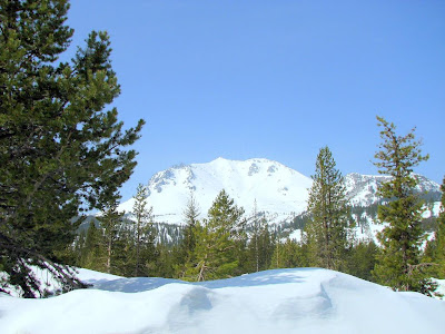
Keith’s perception is that the landscape has changed since 1965, but not dramatically. The primary differences are more snow (that’s just April vs. July), and the trees seem taller. Shown below are two photos taken 43 years apart, from about the same spot. You make your own judgment; whatever change has occurred, it isn’t dramatic.

Friday evening Keith became ill with an intestinal bug, and by Saturday morning was truly under the weather. Since Kathy was not sick, we decided it was probably a bug, as opposed to bad food.
We debated whether to stay an extra day at Hat Creek, or continue on to Timber Valley, an Escapee Park in Sutherlin, OR, where we planned to stay for a week. Keith insisted he was well enough to drive, so we set out on a 5 hour trek. After 80 miles of narrow two lane road we turned onto Interstate 5, and Kathy took over the driving for awhile.


We hope to spend the next week with a pleasant combination of relaxation, chores (the dinette window shade is broken again), touring, and restauranting. There is a promising Chinese Buffet here in Sutherlin, and a couple of Thai restaurants up the road a piece in Roseburg. Stay tuned for phantom COW reports…

No comments:
Post a Comment