Wednesday, June 25, 2008

Alaskan Idyll, Days 6,7 -Whitehorse, YT


Whitehorse was founded during the Klondike Gold Rush of 1898, when thousands of prospectors descended upon the area in search of gold. Today Whitehorse retains much of its historic flavor and has many museums, restaurants, and entertainment opportunities. We were there only 3 days, which is much too short a time to enjoy Whitehorse to its fullest.


Winnebago Goddess Seen in Whitehorse


On Tuesday our group was treated to a 2 hour narrated tour on the Yukon River through Miles Canyon aboard the MV Schwatka. The Yukon was the primary transportation corridor for miners stampeeding to the 1898 gold rush. Miles canyon was the site of dangerous rapids until it was flooded by constructon of a dam in the 20th century. The weather was perfect and we saw a golden eagle as well as a grizzly bear running up the riverbank.

Miles Canyon, Flooded by the Whitehorse Power Dam
Golden Eagle Spotted in Miles Canyon
Bird Houses in Miles Canyon Riverbank


Docked on the lake adjacent to the MV Schwatka were a number of float planes, which are a popular form of local transportation to remote regions in the Yukon and Alaska.
Local Transportation
After our cruise we enjoyed a 3-hour bus tour of Whitehorse, which included stops at SS Klondike II and the Whitehorse Fish way. The SS Klondike II is one of the largest stern-wheelers to have sailed on the Yukon River. It has been fully restored and a guided tour as well as a video is offered.
SS Klondike II


Our stop at the Whitehorse Fish way was less than impressive, as there were no fish climbing the fish ladder.
Whitehorse Fish Ladder, With Power Generating Facilities in the Background


Wednesday was a free day so Keith and I shopped (Wal Mart, grocery store, hardware store) and toured 2 excellent museums.

The first museum we visited was called the Yukon Beringia Interpretive Centre. Beringia was an area of the Yukon, Alaska and Siberia never covered by glaciers during the last ice age. It was a land bridge that allowed people and animals from Asia to migrate to the North American continent. This land bridge emerged as sea level dropped over 300 feet during the last ice age. The center contains many fossils of wooly mammoths, scimitar cats, giant beavers and other animals. The exhibits are well done. We both enjoyed the museum very much.
Globe Showing Beringia Land Bridge (Dark Green)
Beringia Museum Diorama


Our second museum of the afternoon was the Yukon Transportation Museum. This museum focuses on how transportation opened up the Yukon. The museum includes exhibits on the construction of the Alaska Highway and the White Pass and Yukon Railway. We enjoyed this museum very much.
Agressive Driver Spotted at the Whitehorse Transportation Museum
Original Alaska Highway Construction Vehicle


Adjacent to these two museums, at the entrance to the Whitehorse International Airport, is a unique wind vane. It is an old airplane (DC-3?) mounted on a pivot post, which rotates in the breeze. We were told that any wind over 7 miles per hour will turn this aircraft.
Whitehorse International Airport Wind Vane


There is another excellent museum in downtown Whitehorse called the Mcbride, which includes exhibits on the gold rush, First Nations relics, and mining displays. Keith toured this museum in 1998, but we missed it this trip because we ran out of time (and energy).

We were fed two dinners at the campground, one excellent and the other not so good. The excellent meal included a really good grilled steak, baked potato, salad, and Nanaimo bars for dessert. The latter are a tasty northwest specialty; they include layers of chocolate and graham cracker crust, with a crème filling. 3-1/2 COWS for this meal. The other feed was roast beef, mashed potatoes & gravy, peas, carrots, corn, salad, and various desserts. All of this stuff was very good except the beef, which was tasty but completely un-chewable. Overall meal 3 COWs; beef ½ COW.

After our diner on Day 7 we boarded a bus for downtown Whitehorse to see a performance of the “Frantic Follies”, which is a vaudeville revue from the Gold Rush era, complete with Can Can dancers. One of us thought the show was quite funny and entertaining, while the other sat out in the lobby for the second half of the show, after the dancers were finished.
Where it Happens in Whitehorse


We returned to our coach after 11 pm, in full daylight. Tomorrow morning at 9am we head out to Skagway. Stay tuned.
Midnite Sun in Whitehorse

Monday, June 23, 2008

Alaskan Idyll Day 5 - Gas Pains in Whitehorse, YT


Well folks, today was another first. When we arrived at the campground in Whitehorse, YT and filled our gas tank, and the bill was over $200.00! This is the first time we have put that much in our gas tank. As a matter of policy, we try to drive on the top half of the tank on remote highways such as the Alcan. It is not at all uncommon for business such as gas stations to be closed, so we fill up at every opportunity. On today's drive, we were sure we could buy gas in Whitehorse, so we let the tank go down below half, creating an expensive fill-up at $1.44/liter (about 5.50/US gallon).

Our stay in Watson Lake was short and wet, but pleasant nonetheless. The campground, named Baby Nugget, is owned and operated by a husband and wife team, and has been in business since the mid nineties. The campsites are all pull-throughs with electric and water, and are very spacious by commercial park standards, especially on the Alcan. The complex includes a meeting hall (named the “ore house”), a restaurant, a filling station, and, of course, a gift shop. Being about 10 miles west of Watson Lake, the owners have managed to have the business site incorporated as Yukon Town named Nugget. A tasty spaghetti dinner was included in our stay. After dinner the owner told us a little bit about their development of the park, the difficulties of operating a business in such a remote location, and some of her personal history as the only female truck driver on the Cassier Highway in the 1980’s, and her prowess as a backwoods huntress. One of their employees is a woodcarver, and has created an elaborately carved front door for the gift shop. Because of the rain, we did not take out the camera, so we have no pictures of this door.


We left Watson Lake during a drizzly rain and proceeded onward toward Whitehorse. All of the wild animals must have taken the day off, as we saw not one.
Raindrops Keep Falling on My Windshield


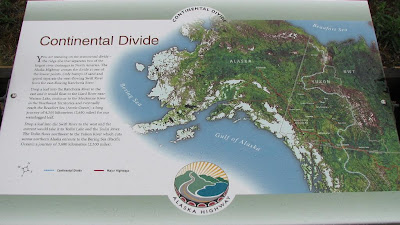
The road between Watson Lake and Whitehorse crosses the Cassier Mountains, a relatively low range which forms the continental divide. Rain which falls on the east side of this divide eventually makes it’s way to the Atlantic Ocean; rain on the west side flows to the Pacific. We had pleanty of rain on both sides of the divide this trip. Keith wanted to deposit some filtered coffee on the Divide, but Kathy restrained him.
A Rainy Day in the Cassier Mountains
Continental Divide
Teslin Lake
Nisutlin Bay Bridge, Longest on the Alcan


Past the Divide we stopped for an early lunch at Dawson’s Peak. We remembered stopping here during our last trip to Alaska. Their specialty is rhubarb pie as well as other home-cooked dishes. We both had beef stew and bumble berry pie, topped with ice cream. (3.5 COWS). Bumble berry pie is a very tasty combination of rhubarb, apple, strawberry and berries. Just your basic 43 dollar lunch.

After lunch the rain stopped and we had glimpses of the sun for the rest of our ride. We arrived in Whitehorse about 3pm .We are staying at the Pioneer RV Park, which is the same park that we stayed at in 2005. Unlike the Baby Nugget, the sites at Pioneer are not spacious or scenic. We are warehoused in with less than 10 feet between coaches. However, we do have full services, including electric, water, sewer, and cable TV. Our satellite TV stopped working in Dawson Creek, and Keith had it suspended for two months, until we are back in the states, so the cable is appreciated. We also have no cell phone service in Whitehorse, which we find somewhat surprising. Our Canadian tail gunners have working service from Canadian Bell. We are surprised that Verizon does not connect through this network. We should have service Skagway, our next stop, which is in the USA.
Stacked Like Cord Wood in Whitehorse


Kathy is especially looking forward to Whitehorse because the last time we were here she had a tooth extracted and missed all of the touring. This evening we were treated to a roast beef dinner at the campground. (2 COWS). The meat was tasty but tough and many of us had a difficult time chewing and digesting it.

Tomorrow we begin to explore Whitehorse; stay tuned.

Sunday, June 22, 2008

Alaskan Idyll, Day 4 - Watson Lake, BC


Today dawned cloudy and rainy. Keith regretted that he was too tired to go out and take pictures of the lake last night while the sun was shining, so the following “mood” shot will have to serve.

Muncho Lake, in a Pensive Mood
Today’s drive was not so spectacular, but was still every bit as scenic as yesterday’s ride through the Rockies. North of Muncho Lake the landscape turns to heavily forested rolling hills. At milepost 476.7 the road crosses the Liard River on the highway’s only remaining suspension bridge, made partially of components salvaged from Galloping Gertie. For those who may not know about it, Galloping Gertie was a suspension bridge over the Tacoma Narrows, which collapsed in a high wind shortly after it opened in 1940. One car was on the bridge when it fell. The driver narrowly escaped by running to the end as the bridge went down. His dog and his car were lost in the disaster, which was filmed by an amateur movie photographer.

Liard River Bridge; Legate of Galloping Gertie

Up the road just a piece, at milepost 477, is Liard Hot Springs Provincial Park. Boardwalks lead to the steaming pools, and changing houses are provided for those who wish to bathe in the warm water. Bears have been a problem here in the past, but we have heard of no recent attacks. Being as it rained most of the day, we did not stop at the springs this trip.

There was significantly less construction and frost damage along this stretch of road, as compared to yesterday’s drive through the mountains. A significant stretch seemed almost brand new, with wide shoulders and moderate grades and curves. As we rode along this improved road we spotted Bison at several locations. It is good to know that this tasty species has not gone entirely extinct.

Bison Bison
At large turnout with picnic facilities is located at Mile 550.9. A cairn near the picnic area is dedicated to Surveyors of the Alaska Highway. A short walk from the cairn is a beautiful view of the Liard River.

Liard River Overlook

At mile 567.9 is Historic Milepost 588 on Contact Creek (see yesterday’s post for discussion of the difference between current highway miles and historic miles). The creek is the site where soldiers working southeast from Whitehorse met troops working northwest from Fort Nelson in September 1942, completing the southern section of the Alcan.

Contact Creek Plaque

Past Contact Creek the highway winds west along the BC-Yukon Border, recrossing the borderline 6 times before reaching g the “official” border post at historic milepost 627.

Welcome to the Yukon!

A unique and interesting “signpost forest” is located in the town of Watson Lake YT. The story goes that in 1942 a lonely soldier erected a sign pointing to his hometown in the lower 48. Other soldiers added their signs, and the “forest” grew from there. Tourists are still adding to the forest, which currently numbers over 60,000 signs. Our Wagonmaster added a sign from our current caravan; Keith was pleased to locate the sign which our group erected in 2005.

Watson Lake Signpost Forest
Memento From 2005 WIT Alaska II Caravan

Saturday, June 21, 2008

Alaskan Idyll Day 3 Muncho Lake, BC


Today’s relatively short (160 mile) journey took us west through the Rocky Mountains from Ft. Nelson to Muncho Lake, BC. A few miles west of Ft. Nelson the road deteriorates somewhat. East of the mountains, the road is newer and wider, with fewer sharp curves. In 1998, when Keith first came this way, it was newly paved and smooth as silk. By 2005, after seven winters, it had become somewhat rougher. After yet three more winters, it’s gotten even rougher.
Approaching the Rocky Mountains
Through the Rockies, the road becomes narrower, with numerous sharp curves with speed limits as slow as 10mph. The road surface also deteriorates further, with numerous short gravel patches. Keith almost missed noting one of these, which happened to be on a downhill lie. Fortunately he spotted it just in time go brake sharply while still on the pavement. Trying to brake while traveling downhill on gravel is a truly exciting experience!
Winding Into the Foothills


Crossing the Tetsa River on the Road to Summit Lake Pass
For two days, we have been hop scotching with a group of vintage sports cars traveling in loose formation. While stopped for gas in Ft. Nelson, Kathy spoke with one of the drivers and learned that they were on a journey from Panama to Alaska. Each driver has picked a charity, and is driving to earn donations.
Vintage Sports Cars Bound from Panama to Alaska


A short distance into the foothills, at milepost 342.8, is Indian Head Mountain. Similar to New Hamshire’s Old Man in the Mountain, before it crumbled, Indian Head is a stone formation which can be seen as a facial profile. The old man was trying to hide in the clouds today.
Indian Head Mountain in a Shy Mood


While on the subject of mileposts, it is interesting to note that there are two kinds of miles (kilometers in Canada) along the Alaska Highway. There are highway miles, and there are historical miles. Highway miles represent the distance along the modern highway from milepost zero in Dawson Creek. Historical miles represent the distance along the original Alaska highway from the same milepost zero. Why are these two mileages different? They are different because the Alcan is shorter than it used to be! Highway improvements over the years have straightened many of the most winding stretches, thereby shortening the total highway length by tens of miles between Dawson Creek and Delta Junction.

There is an annual publication named the milepost, which describes the Northwest Highways mile by mile, including highway and scenic features, commercial services, campgrounds, fishing opportunities, etc. along the road. Many businesses advertise in this essential guide. To locate an establishment, it is necessary note carefully whether their address is a historical or a current milepost number. To further complicate things, the mileposts in Canada are really kilometer posts , and many are missing, victims to either snowplows or souvenir hunters.

As we traveled toward the peak of the Rockies, the sky clouded over. We are not sure if the two factors are linked, but as the sun disappeared we started to see more wildlife.
Foraging in the Rain


At the peak of the Rocky Mountains is Summit Lake Pass, at an altitude of almost 4000ft. Located in the pass is Summit Lake. When the sun is shining, this is a breathtakingly beautiful spot, with the water surrounded by the majestic Rocky Mountain peaks. The lake is just below the tree line, so that the surrounding mountains are bare rock. Not surprisingly, park at the summit is named Stone Mountain Provincial Park. We lunched at Summit Lake, and thoroughly enjoyed it, despite the less than sunny weather.
Summit Lake Looks Lovely in Any Weather
Less Than Exotic Wildlife at Summit Lake
Stone Mountain Hides in the Clouds


Past the summit, winding down along the Toad River, we encountered more wildlife, including moose, caribou, and mountain sheep. Kathy was ecstatic. It rained a bit on the rest of the trip to the campground, but no problems. The mountain valley scenery along this narrow and winding section of the road is fantastic.
Winding Downhill Along the Toad River
Kathy Spots Caribou
Momma Poses for the Camera
Stone Mountain Sheep
Stone Mountain Sheep Exhibit Incredible Climbing Skills
At the end of todays journey we were treated to a ride along the shore of Muncho Lake. We are parked in a campground on the lake, awaiting a travel meeting at 5pm, and dinner at 5:30. Tomorrow we drive on to Watson Lake.
Approaching Muncho Lake

Friday, June 20, 2008

Alaskan Idyll, Day 2 - Ft. Nelson BC


Our first day on the Alcan.

We departed Dawson Creek at 8am this morning, bound north on the Alaska Highway (Alcan) for Fort Nelson, BC.

The Alcan originates in Dawson Creek, and there is a monument to prove it! At 4:30 yesterday afternoon, everyone in our newly assembled caravan boarded a school bus for a group photo at the mile zero monument. We waited a few minutes for the last arrival to join us. They were held up 6 days in Wisconsin after a turkey flew into their windshield. It broke the glass, and damaged the frame. We were so pleased that they were able to catch up with us.


Our WIT Tour Group at Mile Zero

Following the photo op, we re-boarded our bus for a ride to the George Dawson Inn, where we were served a nice roast beast dinner (3 COWs), followed by an entertaining slide show about the Dawson Creek area and the Alaska Highway.

The original Alaska Highway, called the pioneer road, was slashed through the northern wilderness in only 8 months during 1942, shortly after Pearl Harbor, under a perceived threat of imminent invasion by the Japanese. Stretching 1422 miles northwest, the Alcan, as it eventually became known, extended to Delta Junction, Alaska, where it joined the Richardson Highway, which runs from Valdez to Fairbanks. The folks in Fairbanks would like you to believe that their town is the official terminus of the Alcan (or the origin, depending on which way you are traveling), but the Richardson predates the Alcan by about 50 years, so Delta Junction gets the nod.

We were told that the original road cost 17 thousand dollars per mile, re-stated in 2008 dollars. That seems cheap in comparison to a modern interstate highway, which can cost well over a million dollars per mile.

At 8am this morning, our leader dispatched us from the campground, and we began rolling north along the modern Alcan. About 20 miles north of Dawson Creek is the last remaining timber bridge from the original 1942 construction. Called the Kiskatinaw Bridge, it is no longer on the main highway, but is on an 8 mile loop off the original road. We took the detour to view this remnant of the earlier road. With a 24 ton rating, the bridge was more than adequate for us to cross with our 7 ton vehicle.


Rolling North out of Dawson Creek


Kiskatinaw Bridge


A piece of the Original Alcan


A few miles further north the road crosses the Peace River on a large, modern bridge. The descent into the river canyon is steep and winding, as is the ascent on the other side.


Peace River Bridge and Canyon

Not too far north of the Peace River we encountered our first windshield casualty, as we were struck by a stone flung from a passing truck. The windshield has been cracked for some time, but Keith was waiting to replace it until after this trip. Good call. Another Alcan “hazard” is the flies and mosquitoes, some of which are large enough to have four motors. Needless to say, we collected our share to decorate our damaged windshield.


Our First Windshield Casualty


Bugs Decorating our Cracked Windshield

Up the road another 50 miles is Shepherds motel, filling station, and restaurant, where we stopped for a cinnamon roll break. The rolls were large, filling, and tasty. While a tad on the early side, we declared this stop lunch.

Wildlife is one of the features enjoyed by some tourists in this territory. People in our group reported seeing moose, bear, and wild horses on today’s drive. We saw no bear, and the only moose we saw was a motor vehicle casualty, but we did spot a small heard of wild horses.


Critters

As the road proceeds further north it parallels the spine of the Rocky Mountains, rolling along through the foothills like waves marching to the shore.


The Alcan Parallels the Rocky Mountains for Many Miles North of Dawson Creek


Approaching Fort Nelson

Approaching Fort Nelson numerous white, fluffy clouds appeared to contrast with the brilliantly blue sky, but it did not rain. We were glad to arrive at our campground, after the obligatory stop at the local Shell dealer. Our gas bill for the 224 miles since the last fill-up at Fort St. John was $177. This is going to be an expensive trip! Tomorrow we motor west to Muncho Lake, in the heart of the Rocky Mountains. Stay tuned.