Monday, 18 August we terminated our summer idyll and commenced our journey back to New England, where we will reside in our North-Central Massachusetts condominium until after the holidays. In addition to a hectic round of medical appointments, some camping on Cape Cod, and visits with the grandkids in Maryland and Massachusetts, we are planning our wedding at the Publick House in Sturbridge on 22 November. We will head south for the winter after Christmas, as husband and wife.
Why are we squatting in Massachusetts until the snow flies? Because that’s where Kathy’s grandchildren live, that’s why. Any questions?
In prior years, when one or both of were still employed, we would have made the trip east in about 5 days, arriving totally exhausted for our first day back at work. No more! We expect to take about two weeks to get to Maryland, where we will pause a couple of weeks with the Annapolis granddaughters, then a couple more days to travel to Massachusetts.
Details of our first four days are provided below. The balance of the trip east will be incorporated in subsequent posts.
Eastward Bound Day 1 (August 18th) - Banff, AB to Moose Jaw, SK
We left Banff at 6 am the 18th and headed for Moose Jaw, SK, our first destination on the way back to New England.
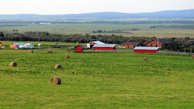
As we drove east on the Trans-Canada Highway, the mountains gradually disappeared, to be replaced with rolling hills and farmlands. As we approached Calgary, the land to flattened out as we entered the Great Plains.
 We Say Good-Bye to the Rocky Mountains
 Dropping Down to the Great Plains as We Approach Calgary
 Agriculture Appears as We Enter the Plains
After Calgary we passed a sign that announced we were entering the “Badlands of Alberta.” The terrain did indeed look like the Dakotas as we passed hundreds of herds of horses and cattle. The Alberta Black Angus Beef are very popular here.
 Cheesebergs On the Hoof
Black Gold is Everywhere on the Alberta Plains
Our next stop was Medicine Hat where we bought gas, had a quick lunch, and photographed the tallest teepee in the world.

The Sign Said This is the Tallest Teepee in the World
Believe What You Wish
As we passed into Saskatchewan, the horizon became totally flat, the land transitioned gradually from mostly grassland to agricultural, with field after field of crops.

Saskatchewan Horizon
 An Agricultural Province
 Prairie Agriculture
We arrived in Moose Jaw about 4:30 and pleasantly cooled off in our air-conditioned camper. Keith had planned to boondock our way across the continent, but the brutal heat forced us into campgrounds with electric service. We could have dry camped and run the generator, but Keith figured that with gas at $4.00 a gallon or higher, the cost to run the generator for 6 or more hours would about equal the camping fee.
Eastward Bound Day 2 (August 19th) - Moose Jaw, SK to Minot, ND
As we headed southeast from Moose Jaw, we continued to pass fields and fields of grain. This area is called the “Breadbasket of Canada” and the name is well deserved. We passed through the town of Weyburn, which is said to be the largest inland collection center for grain in Canada.

Sunrise Over The Saskatchewan Prairie

The Breadbasket of Canada

Agribusiness Near Weyburn
We crossed into the US at North Portal. Crossing the border is always an adventure. This time we had to leave the coach while 3 agents examined our motor home. It took almost half an hour to clear customs and then we were on our way. The big concern was fruits and vegetables this time. Kathy almost landed us in prison by misremembering that she had already consumed a lemon that she mistakenly declared.
 U. S Border Crossing – Site of the Lemon Hunt
Northern North Dakota looks a lot like southern Saskatchewan, with many grain fields. We also started to see fields and fields of sunflowers, which are grown for their seeds.
 Colorful North Dakota Sunflower Crop
 Prairie Lake Near Minot
We arrived in Minot and headed for the Space Aliens Café, a favorite chain of ours in ND. The restaurant is decorated with spacecrafts, cartoon and memorabilia from Roswell and Area 51. Ribs are their specialty. They are prepared Memphis style and are delicious. (3.5 COWS).

North Dakota Home of Surprisingly Good Ribs
We crashed at the Minot KOA, where we spent the night, and Kathy spent 2 hours in their air-conditioned laundry room.
Eastward Bound Day 3 (August 20th) – Minot ND to Moorhead City, MN
The next morning (our third since leaving Banff), we drove to Fargo, bought gas at the J, picked up a new battery transfer solenoid at Pleasureland RV, then drove to another Space Aliens Café for lunch (we really like this chain). Kathy had an alien salad and lunch pizza, while Keith had tortilla soup and a Ruben. (3 COWS).

Jack-O-Lantern Sun seen near Minot

Harvesting North Dakota Wind Energy
After lunch we drove across the Red River to Moorhead, MN where we camped the night at another KOA. A nice campground, reasonably priced (for a KOA), but the half-mile access road is unpaved, and in worse condition than the Top of the World Highway.
Every time we pass through Moorhead we think about looking for the Prairie Home Cemetery, where kids from the local college go to park at night. Having an acute sense of humor, Garrison Keillor named his now famous Saturday night radio show after the companionable activity in this cemetery.
Eastward Bound Days 4&5 (August 21,22) – Moorhead City, MN to Prior Lake, MN
Our fourth eastbound travel day commenced with a drive southeast on I-94 to Rogers, MN, where we paused for an hour of retail therapy at Camping World. Along the way we passed by Charlie’s Café in Freeport, MN, home of the best monster Carmel roll this side of the fictional Chatterbox Café. Charlie’s was mentioned by Garrison Keillor in his National Geographic Article, which is proudly posted in the café. We choose not to stop this trip because we were anticipating a substantial lunch at our destination, and did not wish to over indulge.
Leaving CW with our treasures, we by-passed Minneapolis on the beltway, then motored south a few miles to camp two nights in Prior Lake, home of the Mystic Lake Casino. Because of the heat, we chose to avail ourselves of the casino campground, instead of boon docking. We dined at the casino buffet after arriving, and then Keith hunkered down in the air-conditioned comfort of the motor home, while Kathy fed the tribes.
The next morning, Keith spent a couple of hours installing our new solenoid, while Kathy continued to feed the tribes, in a vain attempt to recoup the prior day’s losses.
Replacement of the solenoid should have been simple, but it is in a somewhat awkward location near the bottom of the battery compartment. In addition, the idiots at Winnebago installed it with ¼-20 Phillips head machine screws, which of course had frozen over the course of seven years, so Keith had to drill them out. However, once the installation was completed, Keith was ecstatic that the new relay fixed our battery-charging problem. Now we can boon dock overnight, confident that the battery will recharge as we drive down the road the next day.
The next morning we departed for points east, as described in a subsequent post. In the meantime, Kathy’s money is feeling very lonely, left behind in the casino without her.


 Our Campsite in Banff Trailer Village
 Bow River Valley
 Downtown Banff
 Bow Falls
 A Banner On Banff Avenue
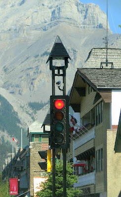
 Banff Avenue Traffic Light
 Could This be Some Sort of New Thrill Ride?
 Polar Bear License Plate from the Northwest Territories
 Flower Gardens at the Canada Center
 Post Card View of the Banff Springs Hotel
 Rolling South on the Icefields Parkway near Jasper
 Rugged Mountain Peaks Look Like
 Note the Variation in Rock Color, From Dark Gray
 Cleavage Steps, Somewhat Rounded by Erosion
 The Western (right) Face of This Steeply Tilted
 Glacially Carved “U” Shaped Valley, With Another
 Columbia Icefield
 Athabasca Glacier Descending From the Icefield
 Columbia Icefield Center, With Ice Buggy on Left
 Ice Buggy Crawls up the Glacier
 Just Another Beautiful River Valley
 Heavily Eroded Mountain Strata
 More Cleavage Steps, Heavily Rounded by Erosion
 Bridge Construction
 Beautiful Clouds Contrast Sharply
 Reflections
 Bike Tour, With Turquoise Colored
+of+IMG_2658_1.JPG) Bruin Warning
Bruin Warning Bruin Lurks on the Roadside
 Wildlife Crossing
 Wildlife Crossing Under Construction