
 Where in the World are Keith and Kathy?
After our visit to Mt. St. Helens, we motored northwest to Kalaloch Campground in the Olympic National Park, where we found a campsite on a bluff overlooking the Pacific Ocean. We stayed four nights with no cell phone, internet, or satellite TV, but we were able to listen to the Tuesday evening election returns on the Sirius satellite radio. Sirius re-broadcasts the CNN and Fox news audio feeds, as well as two channels of NPR and CBC Radio 1. Keith did not especially miss the video feed, but by Friday, when we left, Kathy was showing definite signs of Stage II TV withdrawal.

View from the Picnic Table
It drizzled off and on for our four nights at Kalaloch, but that did not dampen our spirits. The light to moderate winds which brought the rain also brought a light to moderate surf, which made our days pass pleasantly, and soothed our sleep at night.
Directly behind our campsite, at the bottom of the bluff, were stacks of large tree trunks, strewn along the beach as far as the eye could see. These trees are brought down the streams and rivers from the Hoh Rain Forest, on the slopes of the Olympic Mountains. Signs at beach access points warn that these trees kill swimmers in the surf.
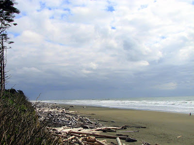
Pacific Beach Driftwood

Bathers be Warned

The Hoh River - A Pacific Beach Driftwood Source
Signs at the campground exit, and along the highway, point the to tsunami evacuation routes. Our last post referred to the Cascadia subduction zone just offshore of the Oregon, Washington and BC coast. In addition to causing the orogeny which has built the Cascade mountains, earthquakes associated with this subduction zone also cause large waves, called tsunamis. Because the subduction zone is not very far offshore, there will be little warning of an impending tsunami wave. The last major tsunami was in 1700. The fault has been unusually quiet since then, presaging a major event when it wakes up again.
Keith did not sleep especially well at Kalaloch, despite the soothing surf.

During our stay, we drove a few miles northeast to visit the Hoh Rain Forest, on the western slopes of the Olympic Mountains. The prevailing westerly breezes bring large quantities of moisture streaming inland from the Pacific Ocean in this area. Much of this moisture condenses in the form of rain on the western slopes of the Olympics, creating the nation’s only temperate rain forest. Characterized by ferns, hanging moss, and other wet climate flora, the Hoh rain forest is a unique and very pleasant environment. There is a National Park Visitors Center, together with paths and boardwalks through representative portions of the forest. This is a dark, but by no means forbidding place. It is not Mirkwood!

The Hoh Rain Forest

This is Not Mirkwood!

A Well Protected Telephone Booth

The Road to Bywater
There are numerous campgrounds in the Olympic National Park. NPS literature indicates that all are limited to RVs less than 21ft. This literature notwithstanding, we found a number of spaces at both Kalaloch and Hoh which were large enough to accommodate our 29’ Winnebago, and a few which might accommodate even larger coaches, so don’t be discouraged by the literature.


